|
|

|
|
|
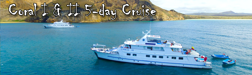
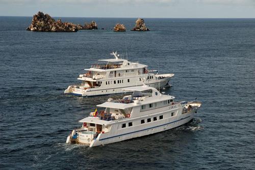
Coral I & II 5-day Cruise
Galapagos
Ecuador
M/YCoral I 36 passengers
M/YCoral II 20 passengers
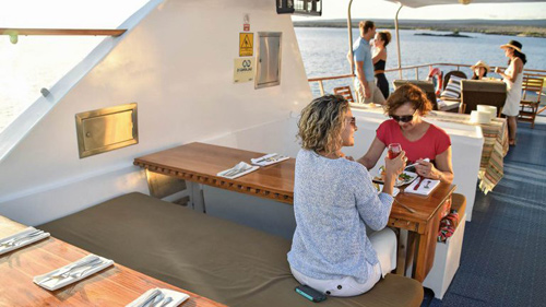
These unique and functional luxury yachts are a perfect combination of classic beauty and exquisite style. The materials used in their decoration convey a pleasing sensation of warmth and comfort that will transport you automatically into a marine environment. You will be a part of nature thanks to the ample panoramic windows. Every single detail has been taken into consideration to make your stay on board unique and unforgettable. The jacuzzi, sun and shadow decks will give you a perfect space to relax. The social areas and the bar will be a place to enjoy.
Relax
To relax in the sun or even bathe in the jacuzzi, head to the M/Y Coral I outside decks, where the natural wonders of the Galapagos can be enjoyed from a whole different perspective, whether by the handrail of their decks, the comfort of a sun-lounger or from the balcony at the bow. There’s a space for everyone on these deceptively large yachts. Our lounge offers indoor relaxation if you're wanting a break from the sun.
Enjoy
Enjoy the various activities on board. On board our ship, nights are magical, full of bright stars and countless constellations. You can go shopping at our boutique, or enjoy a freshening drink at the bar.
Learn
All of our highly-qualified multi-lingual naturalist guides are certified by the Galapagos National Park. On visits to the islands, they will accompany you every step of the way, taking time to explain the highlights as you wonder through this new and magical land. Every evening, these same guides will give you a lecture illustrated with multimedia presentation, imparting and sharing with you their knowledge of geology, history, evolution, flora and fauna of the islands. Enjoy our library to further enhance your experience.
Feel Safe
Our customers’ safety and the conservation and respect for the environment are our main priorities. Our vessels comply with local and international standards enforced by ISM (International Management Code for the Safe Operation of Ships and for Pollution Prevention). Our crews are all highly trained in safety procedures and have years of experience at sea.
|
|
|
Rates and Dates for 2024
Rates include*:
Accommodation, All meals, Welcome & farewell cocktails, Coffee / tea station, 2 daily excursions, Multilingual naturalist guides (English/Spanish), Snorkeling opportunities, Optional Diving, Fuel surcharge, Free Shuttle service from Quito/Guayaquil Airport-roundtrip (when domestic flight is purchased in combination with cruises)
Guides speaking French, German and Italian upon request
| A | 2024 | 5 day Deluxe Cruise, Standard Interior- West (High) | 5d / 4n | $2525 |
| Upgrade to Standard Plus, pp | $600 |
| Upgrade to Junior Suite, pp | $1040 |
| B | 2024 | 5 day Deluxe Cruise, Standard Interior- South (High) | 5d / 4n | $2525 |
| Upgrade to Standard Plus, pp | $600 |
| Upgrade to Junior Suite, pp | $1040 |
| C | 2024 | 5 day Deluxe Cruise, Standard Interior- West (Low) | 5d / 4n | $2505 |
| Upgrade to Standard Plus, pp | $600 |
| Upgrade to Junior Suite, pp | $1035 |
| D | 2024 | 5 day Deluxe Cruise, Standard Interior- South (Low) | 5d / 4n | $2505 |
| Upgrade to Standard Plus, pp | $600 |
| Upgrade to Junior Suite, pp | $1035 |
�����������������������������������������������������������������������������������������������������������������������������������������������������������������������������������������������������������������������������������������������������������������������������������������������������������������������������������������������������������������������������������������������������������������������������������������������������������������������������������������������������������������������������������������������������������������������������������������������������������������������������������������������������������������������������������������������������������������������������������������������������������������������������������������������������������������������������������������������������������������������������������������������������������������������������������������������������������������������������������������������������������������������������������������������������������������������������������������������������������������������������������������������������������������������������������������������������������������������������������������������������������������������������������������������������������������������������������������������������������������������������������������������������������������������������������������������������������������������������������������������������������������������������������������������������������������������������������������������������������������������������������������������������������������������������������������������������������������������������������������������������������������������������������������������������������������������������������������������������������������������������������������������������������������������������������������������������������������������������������������������������������������������������������������������������������������������������������������������������������������������������������������������������������������������������������������������������������������������������������������������������������������������������������������������������������������������������������������������������������������������������������������������������������������������������������������������������������������������������������������������������������������������������������������������������������������������������������������������������������������������������������������������������������������������������������������������������������������������������������������������������������������������������������������������������������������������������������������������������������������������������������������������������������������������������������������������������������������������������������������������������������������������������������������������������������������������������������������������������������������������������������������������������������������������������������������������������������������������������������������������������������������������������������������������������������������������������������������������������������������������������������������������������������������������������������������������������������������������������������������������������������������������������������������������������������������������������������������������������������������������������������������������������������������������������������������������������������������������������������������������������������������������������������������������������������������������������������������������������������������������������������������������������������������������������������������������������������������������������������������������������������������������������������������������������������������������������������������������������������������������������������������������������������������������������������������������������������������������������������������������������������������������������������������������������������������������������������������������������������������������������������������������������������������������������������������������������������������������������������������������������������������������������������������������������������������������������������������������������������������������������������������������������������������������������������������������������������������������������������������������������������������������������������������������������������������������������������������������������������������������������������������������������������������������������������������������������������������������������������������������������������������������������������������������������������������������������������������������������������������������������������������������������������������������������������������������������������������������������������������������������������������������������������������������������������������������������������������������������������������������������������������������������������������������������������������������������������������������������������������������������������������������������������������������������������������������������������������������������������������������������������������������������������������������������������������������������������������������������������������������������������������������������������������������������������������������������������������������������������������������������������������������������������������������������������������������������������������������������������������������������������������������������������������������������������������������������������������������������������������������������������������������������������������������������������������������������������������������������������������������������������������������������������������������������������������������������������������������������������������������������������������������������������������������������������������������������������������������������������������������������������������������������������������������������������������������������������������������������������������������������������������������������������������������������������������������������������������������������������������������������������������������������������������������������������������������������������������������������������������������������������������������������������������������������������������������������������������������������������������������������������������������������������������������������������������������������������������������������������������������������������������������������������������������������������������������������������������������������������������������������������������������������������������������������������������������������������������������������������������������������������������������������������������������������������������������������������������������������������������������������������������������������������������������������������������������������������������������������������������������������������������������������������������������������������������������������������������������������������������������������������������������������������������������������������������������������������������������������������������������������������������������������������������������������������������������������������������������������������������������������������������������������������������������������������������������������������������������������������������������������������������������������������������������������������������������������������������������������������������������������������������������������������������������������������������������������������������������������������������������������������������������������������������������������������������������������������������������������������������������������������������������������������������������������������������������������������������������������������������������������������������������������������������������������������������������������������������������������������������������������������������������������������������������������������������������������������������������������������������������������������������������������������������������������������������������������������������������������������������������������������������������������������������������������������������������������������������������������������������������������������������������������������������������������������������������������������������������������������������������������������������������������������������������������������������������������������������������������������������������������������������������������������������������������������������������������������������������������������������������������������������������������������������������������������������������������������������������������������������������������������������������������������������������������������������������������������������������������������������������������������������������������������������������������������������������������������������������������������������������������������������������������������������������������������������������������������������������������������������������������������������������������������������������������������������������������������������������������������������������������������������������������������������������������������������������������������������������������������������������������������������������������������������������������������������������������������������������������������������������������������������������������������������������������������������������������������������������������������������������������������������������������������������������������������������������������������������������������������������������������������������������������������������������������������������������������������������������������������������������������������������������������������������������������������������������������������������������������������������������������������������������������������������������������������������������������������������������������������������������������������������������������������������������������������������������������������������������������������������������������������������������������������������������������������������������������������������������������������������������������������������������������������������������������������������������������������������������������������������������������������������������������������������������������������������������������������������������������������������������������������������������������������������������������������������������������������������������������������������������������������������������������������������������������������������������������������������������������������������������������������������������������������������������������������������������������������������������������������������������������������������������������������������������������������������������������������������������������������������������������������������������������������������������������������������������������������������������������������������������������������������������������������������������������������������������������������������������������������������������������������������������������������������������������������������������������������������������������������������������������������������������������������������������������������������������������������������������������������������������������������������������������������������������������������������������������������������������������������������������������������������������������������������������������������������������������������������������������������������������������������������������������������������������������������������������������������������������������������������������������������������������������������������������������������������������������������������������������������������������������������������������������������������������������������������������������������������������������������������������������������������������������������������������������������������������������������������������������������������������������������������������������������������������������������������������������������������������������������������������������������������������������������������������������������������������������������������������������������������������������������������������������������������������������������������������������������������������������������������������������������������������������������������������������������������������������������������������������������������������������������������������������������������������������������������������������������������������������������������������������������������������������������������������������������������������������������������������������������������������������������������������������������������������������������������������������������������������������������������������������������������������������������������������������������������������������������������������������������������������������������������������������������������������������������������������������������������������������������������������������������������������������������������������������������������������������������������������������������������������������������������������������������������������������������������������������������������������������������������������������������������������������������������������������������������������������������������������������������������������������������������������������������������������������������������������������������������������������������������������������������������������������������������������������������������������������������������������������������������������������������������������������������������������������������������������������������������������������������������������������������������������������������������������������������������������������������������������������������������������������������������������������������������������������������������������������������������������������������������������������������������������������������������������������������������������������������������������������������������������������������������������������������������������������������������������������������������������
Minimum Deposit:
~$500.00 per person
* prices are per person based on double/twin occupancy
Rates Note:
The transit card fee and the Galapagos entrance fee must be paid to the CGG (Consejo de Gobierno de Galapagos) at the airport in cash.
Transfer and Other Charges:
|
2024
|
Air ticket from Quito/ Guayaquil to Galapagos, per adult, roundtrip
|
$495
|
|
2024
|
Transfer from Quito/ Guayquil Airport (if airfare not booked) - please inquire (Mandatory)
|
$0
|
|
2024
|
Single Supplement: +50% on standard (+75% on holiday season)
|
$0
|
|
2024
|
Child discount (under 12) - please inquire
|
$0
|
|
2024
|
Triple room discount - please inquire
|
$0
|
|
2024
|
CGG Migration Card (mandatory), pp
- to be paid locally
|
$20
|
|
2024
|
Entrance fee to Galapagos (mandatory), per adult - effective until end of July 2024
- to be paid locally
|
$100
|
|
2024
|
Entrance fee to Galapagos (mandatory), per child under 12 - effective until end of July 2024
- to be paid locally
|
$50
|
|
2024
|
Entrance fee to Galapagos (mandatory), per adult - effective from August 1, 2024
- to be paid locally
|
$200
|
|
2024
|
Entrance fee to Galapagos (mandatory), per child under 12 - effective from August 1, 2024
- to be paid locally
|
$100
|
Pick-up/ drop-off is from Baltra Airport (GPS) or San Cristobal Airport (SCY) depending on the itinerary booked.
Tour Dates for 2024
Check here for details and availability
|
| D |
2024
|
02/25
- 02/29
|
5d / 4n
|
5 day Deluxe Cruise, Standar...
|
8
/36
|
Expired
|
| C |
2024
|
02/25
- 02/29
|
5d / 4n
|
5 day Deluxe Cruise, Standar...
|
8
/36
|
Expired
|
| C |
2024
|
03/03
- 03/07
|
5d / 4n
|
5 day Deluxe Cruise, Standar...
|
8
/36
|
Expired
|
| D |
2024
|
03/03
- 03/07
|
5d / 4n
|
5 day Deluxe Cruise, Standar...
|
8
/36
|
Expired
|
| D |
2024
|
03/10
- 03/14
|
5d / 4n
|
5 day Deluxe Cruise, Standar...
|
8
/36
|
Expired
|
| C |
2024
|
03/10
- 03/14
|
5d / 4n
|
5 day Deluxe Cruise, Standar...
|
8
/36
|
Expired
|
| C |
2024
|
03/17
- 03/21
|
5d / 4n
|
5 day Deluxe Cruise, Standar...
|
8
/36
|
Expired
|
| D |
2024
|
03/17
- 03/21
|
5d / 4n
|
5 day Deluxe Cruise, Standar...
|
8
/36
|
Expired
|
| D |
2024
|
03/24
- 03/28
|
5d / 4n
|
5 day Deluxe Cruise, Standar...
|
8
/36
|
Expired
|
| C |
2024
|
03/24
- 03/28
|
5d / 4n
|
5 day Deluxe Cruise, Standar...
|
8
/36
|
Expired
|
| C |
2024
|
03/31
- 04/04
|
5d / 4n
|
5 day Deluxe Cruise, Standar...
|
8
/36
|
Expired
|
| D |
2024
|
03/31
- 04/04
|
5d / 4n
|
5 day Deluxe Cruise, Standar...
|
8
/36
|
Expired
|
| D |
2024
|
04/07
- 04/11
|
5d / 4n
|
5 day Deluxe Cruise, Standar...
|
8
/36
|
Expired
|
| C |
2024
|
04/07
- 04/11
|
5d / 4n
|
5 day Deluxe Cruise, Standar...
|
8
/36
|
Expired
|
| C |
2024
|
04/14
- 04/18
|
5d / 4n
|
5 day Deluxe Cruise, Standar...
|
8
/36
|
Expired
|
| D |
2024
|
04/14
- 04/18
|
5d / 4n
|
5 day Deluxe Cruise, Standar...
|
8
/36
|
Expired
|
| D |
2024
|
04/18
- 04/22
|
5d / 4n
|
5 day Deluxe Cruise, Standar...
|
8
/36
|
Expired
|
| C |
2024
|
04/18
- 04/22
|
5d / 4n
|
5 day Deluxe Cruise, Standar...
|
8
/36
|
Expired
|
| D |
2024
|
04/21
- 04/25
|
5d / 4n
|
5 day Deluxe Cruise, Standar...
|
8
/36
|
Expired
|
| C |
2024
|
04/21
- 04/25
|
5d / 4n
|
5 day Deluxe Cruise, Standar...
|
8
/36
|
Expired
|
| D |
2024
|
05/05
- 05/09
|
5d / 4n
|
5 day Deluxe Cruise, Standar...
|
8
/36
|
Reserve
|
| C |
2024
|
05/05
- 05/09
|
5d / 4n
|
5 day Deluxe Cruise, Standar...
|
8
/36
|
Reserve
|
| C |
2024
|
05/12
- 05/16
|
5d / 4n
|
5 day Deluxe Cruise, Standar...
|
8
/36
|
Reserve
|
| D |
2024
|
05/12
- 05/16
|
5d / 4n
|
5 day Deluxe Cruise, Standar...
|
8
/36
|
Reserve
|
| D |
2024
|
05/19
- 05/23
|
5d / 4n
|
5 day Deluxe Cruise, Standar...
|
8
/36
|
Reserve
|
| C |
2024
|
05/19
- 05/23
|
5d / 4n
|
5 day Deluxe Cruise, Standar...
|
8
/36
|
Reserve
|
| C |
2024
|
05/26
- 05/30
|
5d / 4n
|
5 day Deluxe Cruise, Standar...
|
8
/36
|
Reserve
|
| D |
2024
|
05/26
- 05/30
|
5d / 4n
|
5 day Deluxe Cruise, Standar...
|
8
/36
|
Reserve
|
| D |
2024
|
06/02
- 06/06
|
5d / 4n
|
5 day Deluxe Cruise, Standar...
|
8
/36
|
Reserve
|
| C |
2024
|
06/02
- 06/06
|
5d / 4n
|
5 day Deluxe Cruise, Standar...
|
8
/36
|
Reserve
|
| C |
2024
|
06/09
- 06/13
|
5d / 4n
|
5 day Deluxe Cruise, Standar...
|
8
/36
|
Reserve
|
| D |
2024
|
06/09
- 06/13
|
5d / 4n
|
5 day Deluxe Cruise, Standar...
|
8
/36
|
Reserve
|
| D |
2024
|
06/16
- 06/20
|
5d / 4n
|
5 day Deluxe Cruise, Standar...
|
8
/36
|
Reserve
|
| C |
2024
|
06/16
- 06/20
|
5d / 4n
|
5 day Deluxe Cruise, Standar...
|
8
/36
|
Reserve
|
| C |
2024
|
06/23
- 06/27
|
5d / 4n
|
5 day Deluxe Cruise, Standar...
|
8
/36
|
Reserve
|
| D |
2024
|
06/23
- 06/27
|
5d / 4n
|
5 day Deluxe Cruise, Standar...
|
8
/36
|
Reserve
|
| D |
2024
|
06/30
- 07/04
|
5d / 4n
|
5 day Deluxe Cruise, Standar...
|
8
/36
|
Reserve
|
| C |
2024
|
06/30
- 07/04
|
5d / 4n
|
5 day Deluxe Cruise, Standar...
|
8
/36
|
Reserve
|
| C |
2024
|
07/07
- 07/11
|
5d / 4n
|
5 day Deluxe Cruise, Standar...
|
8
/36
|
Reserve
|
| D |
2024
|
07/07
- 07/11
|
5d / 4n
|
5 day Deluxe Cruise, Standar...
|
8
/36
|
Reserve
|
| D |
2024
|
07/14
- 07/18
|
5d / 4n
|
5 day Deluxe Cruise, Standar...
|
8
/36
|
Reserve
|
| C |
2024
|
07/14
- 07/18
|
5d / 4n
|
5 day Deluxe Cruise, Standar...
|
8
/36
|
Reserve
|
| C |
2024
|
07/21
- 07/25
|
5d / 4n
|
5 day Deluxe Cruise, Standar...
|
8
/36
|
Reserve
|
| D |
2024
|
07/21
- 07/25
|
5d / 4n
|
5 day Deluxe Cruise, Standar...
|
8
/36
|
Reserve
|
| D |
2024
|
07/28
- 08/01
|
5d / 4n
|
5 day Deluxe Cruise, Standar...
|
8
/36
|
Reserve
|
| C |
2024
|
07/28
- 08/01
|
5d / 4n
|
5 day Deluxe Cruise, Standar...
|
8
/36
|
Reserve
|
| C |
2024
|
08/04
- 08/08
|
5d / 4n
|
5 day Deluxe Cruise, Standar...
|
8
/36
|
Reserve
|
| D |
2024
|
08/04
- 08/08
|
5d / 4n
|
5 day Deluxe Cruise, Standar...
|
8
/36
|
Reserve
|
| D |
2024
|
08/11
- 08/15
|
5d / 4n
|
5 day Deluxe Cruise, Standar...
|
8
/36
|
Reserve
|
| C |
2024
|
08/11
- 08/15
|
5d / 4n
|
5 day Deluxe Cruise, Standar...
|
8
/36
|
Reserve
|
| C |
2024
|
08/18
- 08/22
|
5d / 4n
|
5 day Deluxe Cruise, Standar...
|
8
/36
|
Reserve
|
| D |
2024
|
08/18
- 08/22
|
5d / 4n
|
5 day Deluxe Cruise, Standar...
|
8
/36
|
Reserve
|
| D |
2024
|
08/25
- 08/29
|
5d / 4n
|
5 day Deluxe Cruise, Standar...
|
8
/36
|
Reserve
|
| C |
2024
|
08/25
- 08/29
|
5d / 4n
|
5 day Deluxe Cruise, Standar...
|
8
/36
|
Reserve
|
| C |
2024
|
09/01
- 09/05
|
5d / 4n
|
5 day Deluxe Cruise, Standar...
|
8
/36
|
Reserve
|
| D |
2024
|
09/01
- 09/05
|
5d / 4n
|
5 day Deluxe Cruise, Standar...
|
8
/36
|
Reserve
|
| D |
2024
|
09/08
- 09/12
|
5d / 4n
|
5 day Deluxe Cruise, Standar...
|
8
/36
|
Reserve
|
| C |
2024
|
09/08
- 09/12
|
5d / 4n
|
5 day Deluxe Cruise, Standar...
|
8
/36
|
Reserve
|
| C |
2024
|
09/15
- 09/19
|
5d / 4n
|
5 day Deluxe Cruise, Standar...
|
8
/36
|
Reserve
|
| D |
2024
|
09/15
- 09/19
|
5d / 4n
|
5 day Deluxe Cruise, Standar...
|
8
/36
|
Reserve
|
| D |
2024
|
09/22
- 09/26
|
5d / 4n
|
5 day Deluxe Cruise, Standar...
|
8
/36
|
Reserve
|
| C |
2024
|
09/22
- 09/26
|
5d / 4n
|
5 day Deluxe Cruise, Standar...
|
8
/36
|
Reserve
|
| C |
2024
|
09/29
- 10/03
|
5d / 4n
|
5 day Deluxe Cruise, Standar...
|
8
/36
|
Reserve
|
| D |
2024
|
09/29
- 10/03
|
5d / 4n
|
5 day Deluxe Cruise, Standar...
|
8
/36
|
Reserve
|
| D |
2024
|
10/06
- 10/10
|
5d / 4n
|
5 day Deluxe Cruise, Standar...
|
8
/36
|
Reserve
|
| C |
2024
|
10/06
- 10/10
|
5d / 4n
|
5 day Deluxe Cruise, Standar...
|
8
/36
|
Reserve
|
| C |
2024
|
10/13
- 10/17
|
5d / 4n
|
5 day Deluxe Cruise, Standar...
|
8
/36
|
Reserve
|
| D |
2024
|
10/13
- 10/17
|
5d / 4n
|
5 day Deluxe Cruise, Standar...
|
8
/36
|
Reserve
|
| D |
2024
|
10/20
- 10/24
|
5d / 4n
|
5 day Deluxe Cruise, Standar...
|
8
/36
|
Reserve
|
| C |
2024
|
10/20
- 10/24
|
5d / 4n
|
5 day Deluxe Cruise, Standar...
|
8
/36
|
Reserve
|
| C |
2024
|
10/27
- 10/31
|
5d / 4n
|
5 day Deluxe Cruise, Standar...
|
8
/36
|
Reserve
|
| D |
2024
|
10/27
- 10/31
|
5d / 4n
|
5 day Deluxe Cruise, Standar...
|
8
/36
|
Reserve
|
| D |
2024
|
11/03
- 11/07
|
5d / 4n
|
5 day Deluxe Cruise, Standar...
|
8
/36
|
Reserve
|
| C |
2024
|
11/03
- 11/07
|
5d / 4n
|
5 day Deluxe Cruise, Standar...
|
8
/36
|
Reserve
|
| C |
2024
|
11/10
- 11/14
|
5d / 4n
|
5 day Deluxe Cruise, Standar...
|
8
/36
|
Reserve
|
| D |
2024
|
11/10
- 11/14
|
5d / 4n
|
5 day Deluxe Cruise, Standar...
|
8
/36
|
Reserve
|
| D |
2024
|
11/17
- 11/21
|
5d / 4n
|
5 day Deluxe Cruise, Standar...
|
8
/36
|
Reserve
|
| C |
2024
|
11/17
- 11/21
|
5d / 4n
|
5 day Deluxe Cruise, Standar...
|
8
/36
|
Reserve
|
| C |
2024
|
11/24
- 11/28
|
5d / 4n
|
5 day Deluxe Cruise, Standar...
|
8
/36
|
Reserve
|
| D |
2024
|
11/24
- 11/28
|
5d / 4n
|
5 day Deluxe Cruise, Standar...
|
8
/36
|
Reserve
|
| D |
2024
|
12/01
- 12/05
|
5d / 4n
|
5 day Deluxe Cruise, Standar...
|
8
/36
|
Reserve
|
| C |
2024
|
12/01
- 12/05
|
5d / 4n
|
5 day Deluxe Cruise, Standar...
|
8
/36
|
Reserve
|
| C |
2024
|
12/08
- 12/12
|
5d / 4n
|
5 day Deluxe Cruise, Standar...
|
8
/36
|
Reserve
|
| D |
2024
|
12/08
- 12/12
|
5d / 4n
|
5 day Deluxe Cruise, Standar...
|
8
/36
|
Reserve
|
| D |
2024
|
12/15
- 12/19
|
5d / 4n
|
5 day Deluxe Cruise, Standar...
|
8
/36
|
Reserve
|
| C |
2024
|
12/15
- 12/19
|
5d / 4n
|
5 day Deluxe Cruise, Standar...
|
8
/36
|
Reserve
|
|
Weekly departures Wednesday to Sunday
|
Rates do not include:
Drinks, Air ticket from Quito/ Guayaquil to Galapagos (can be booked for extra fee), Galapagos Entrance Fee (mandatory), CGG Migration Control Card (mandatory), Gratuities, Travel insurance, Gratuities, Snorkelling / diving equipment & Wet suits / kayak rentals
Sample Itinerary: West option - subject to changes
Day 1 (Sunday): Arrival & Santa Cruz Island Visit
Departure from Quito or Guayaquil to Baltra Island (approx. 2½-hour flight). Arriving in the Galapagos, passengers are picked up at the airport by our naturist guides and taken on a ten-minute bus drive to the pier to board the M/Y Coral I or M/Y Coral II.
This afternoon, dry landing on Santa Cruz Island. In the mountains of Galapagos, it is possible to admire different kinds of birds, such as tree and ground finches, vermillion flycatchers, paint-billed crakes, yellow warblers, and cattle egrets (usually standing on the tortoises’ shell). The journey to the reserve offers great opportunities to see the contrasts that the island offers in reference to the variety of ecosystems. The road goes from the coast through the agricultural zone and straight up to the dense humid forests. Often, Galapagos Giant Tortoises are also seen on the way, wandering through pastures in the paddocks. This spot is a birdwatchers’ haven since almost every land bird present on the island lives or migrates here.
Activity Difficulty: easy (flat & muddy terrain depending on season)
Activity Duration: 45-minute drive / 1 ½-hour walk
Day 2 (Monday): Isabela & Fernandina Islands
Vicente Roca Point (Isabela Island) is a high peak of land created out of remains of a tuff cone, with two protected turquoise coves on both sides. One of them, the Bolivar Channel is one of the richest marine ecosystems on Earth. This place is only accessible by water, with great opportunities for deep-water snorkeling. In this part of the Galapagos, the upwelling of cold water currents from the west, offer an abundant plankton supply for marine species like red-lipped batfish, seahorses, frogfish, nudibranchs, octopus, and the mola-mola or sunfish. It is common to observe dolphin pods, sea lions rafts, and tuna banks. The dinghy ride along the coast will allow observing a great diversity of seabirds like noddies, brown pelicans, Galapagos penguins, flightless cormorants, Nazca and Blue-footed boobies are often seen feeding all at once during the cold season (May – December). Whale watching is also common while navigating.
Activity Difficulty: intermediate
Activity Duration: 1-hour snorkeling / 1-hour dinghy ride
After lunch, dry landing on Fernandina Island. From Espinosa Point, is possible to admire a wide view of Isabela Island across the Bolivar Channel, an area that hosts some of the highest diversity of endemic sea fauna in the Galapagos. Here, the largest most primitive-looking marine iguanas are found mingling with sea lions and sally Lightfoot Crabs. Fernandina island displays a wonderful opportunity to encounter flightless cormorants at their nesting sites. The Galapagos penguins and the “King” of predators on the islands, the Galapagos Hawk, can also be spotted. Pa-hoe-hoe and AA lava formations cover the majority of Fernandina terrain. Vegetation is scarce inland, with the exception of a few brachycereus cacti. In the shore, mangrove can be found.
Activity Difficulty: intermediate (rocky terrain)
Activity Duration: 2-hours walk / 1-hour snorkeling
Day 3 (Tuesday): Isabela Island
We start the day with a wet landing in Urbina Bay (might be difficult due to the tide). Volcanic black beach, depending on the season, it is possible to find giant tortoises, land iguanas, and the unusual flightless cormorant. After a short walk inland it´s snorkeling time, a chance to swim with sea turtles, sea lions, and countless tropical fish. Urbina Bay features a wide variety of plants with the different range of colors in flowers, attracting different insects, birds, and reptiles. One of the highlights of the island is the uplifted coral reef that resulted from the 1954 seismic activity; here the views of Alcedo Volcano are remarkable. When navigating from Urbina to Tagus Cove whale watching is usual in May – December.
Activity Difficulty: intermediate (flat & rocky terrain)
Activity Duration: 1 ½-hour walk / 1-hour snorkeling
This afternoon, dry landing in Tagus Cove, on Galapagos’ largest island (Isabela) where we will learn about the eruption of the five volcanoes that form it. The trail leads to Darwin’s salt-water crater lake and excellent views of lava fields and volcanic formations.We will return by the same path for a dinghy ride along a shoreline full of marine wildlife, where we will admire a variety of seabirds, such as Blue-footed Booby, Brown Noddy, terns, Flightless Cormorant and depending on the season, a large number of Galapagos Penguins which are only 35 cm tall; the only penguin species in the world to live in the tropics.
The population of penguins on the islands is about 2,000 individuals, most of which live on this western portion of Isabela; others are scattered further south. We will have an opportunity to snorkel in deep water. Graffiti believed to have been left by 19th-century pirates is a curious reminder of an intriguing past.
Activity Difficulty: intermediate / difficult (steep)
Activity Duration: 2-hour walk / 40-minutes dinghy ride / 1-hour deep water snorkeling
Day 4 (Wednesday): Santiago Island
After breakfast, wet landing at Egas Port, a black volcanic sand beach, visited by Darwin in 1835. The first section of the trail is formed of volcanic ash (eroded tuff) and the other half is an uneven terrain of volcanic basaltic rock. The unique, truly striking layered terrain of Santiago shore is home to a variety of animals including the bizarre yellow-crowned night heron and marine wildlife including lobster, starfish and marine iguanas grazing on algae beds alongside Sally light-foot crabs. It is easy to see colonies of endemic fur seals swimming in cool water volcanic rock pools.
Activity Difficulty: intermediate (flat & semi-rocky terrain)
Activity Duration: 1½-hour walk / 1-hour snorkeling
Later that day, wet landing in Sullivan Bay. This site located at the southeastern portion of Santiago Island is of important geologic interest. It features extensive relative young pa-hoe-hoe lava flows formed during the last quarter of the 19th century. In the middle of the lava flow, older reddish-yellow-colored tuff cones appear. Mollugo plants with their yellow-to-orange whorled leaves usually grow out of the fissures. Walking on the solidified lava gives the impression of been in another planet. Tree molds are found, indicating that in that position large size plants grew in small crevices, until the lava flow of past eruptions burned down the flora of the island.
Activity Difficulty: difficult (flat volcanic lava)
Activity Duration: 1½-hour walk / 1-hour snorkeling / beach time
Day 5 (Thursday): Departure
For our last morning, wet landing on Bachas Beach. On the north side of Santa Cruz; behind the beach lies two small flamingo ponds were iguanas sunbathe, see coastal birds, Darwin finches, mockingbirds, and gulls, as well as interesting native vegetation like red and black mangrove, salt bushes. This beach is one of the main sea turtles nesting sites in the Galapagos. A turtle can lay eggs 3 or 4 times per season with an average of 70 eggs each time. At this paradisiacal site, we will also find the remains of barges that sank a long time ago, when the United States Navy operated a base during World War II on Baltra Island. Local people modified the word barges to “Bachas”.
Activity Difficulty: easy (sandy terrain)
Activity Duration: 1-hour walk / 1-hour snorkeling/ beach time
After the visit, passengers will be transferred to the airport for their return flight to Guayaquil or Quito.
Sample Itinerary: South option - subject to changes
Day 1 (Sunday): Arrival & San Cristobal Island Visit
Departure from Quito or Guayaquil to San Cristobal (2 1/2 hours flight). Arriving in Galapagos, passengers are picked up at the airport by our naturalist guides and taken to the pier to board the M/Y Coral I or M/Y Coral II.
We start the afternoon with a dry landing in Puerto Baquerizo Moreno, the capital of the Galapagos Islands (San Cristobal Island). Passengers visit the Interpretation Center, an excellent place to learn about islands’ history in The Museum of Natural History which displays information about the volcanic origins of the islands, their remoteness from the continent, ocean currents, climate, the arrival of the different species and their colonization, among other points of interest. The human history is also showcased, chronologically narrating the most significant events related to the discovery and the island’s colonization.
Activity Difficulty: easy / intermediate (flat terrain with stairs)
Activity Duration: 1-hour visit / 1-hour walk
Later that day, we visit Tijeretas Hill, which involves a high-intensity walk amidst beautiful landscapes and a magnificent view at the foot of a frigate bird nesting colony.
Activity Difficulty: difficult (rocky terrain)
Activity Duration: 1-hour visit
Day 2 (Monday): San Cristobal Island
We start the day with wet landing at Cerro Brujo, an eroding tuff cone that is composed of AA lava formations; it is close to a beautiful white sandy beach which is great for snorkeling and sunbathing. Nearby a lagoon ideal for migratory bird species can be seen, including black-necked stilts, ruddy turnstones, whimbrels, sandpiper, and white- cheeked Pintails. Cerro Brujo offers beautiful views of Kicker Rock, an islet in the adjacent southern coast of San Cristobal.
Activity Difficulty: easy (sandy terrain)
Activity Duration: 1-hour walk / 1-hour snorkeling
This afternoon, wet landing followed by a high-intensity hike at Pitt Point. The trail includes a 90 meters long, olivine beach and a path that climbs to the top of a volcanic tuff, through several magnificent viewpoints. This is probably the only site where the three booby species of the Galapagos can be seen together, as well as, two species of frigate birds and a sea lion colony. It is also excellent for dinghy rides and snorkeling, where a good range of sea birds can be observed.
Activity Difficulty: difficult (rocky terrain)
Activity Duration: 2½-hour walk/ 40-minutes snorkeling or kayaking
Day 3 (Tuesday): Espanola Island
After breakfast, dry landing at Suarez Point, on Espanola Island. Espanola is an island of geological interest, being one of the oldest in Galapagos, it has a high percentage of endemism due to its isolation from the rest of the islands. Due to the great variety of wildlife, this is one of the most attractive spots in the Galapagos. Here, it is possible to explore volcanic formations and see large colonies of sea lion and seabirds including the Española mockingbird, Nazca boobies, and the spectacular red-billed tropicbirds. Here, the singular marine iguanas have a turquoise color with reddish parts during the breeding season, lava lizards, and the colorful Sally light-foot crabs. A somewhat lengthy hike brings visitors to nesting grounds that sometimes overlap the trail. Other birdwatchers favorites include the Galapagos dove, the Galapagos hawk, swallow-tailed gulls and the world’s largest colony of waved albatross, an unequivocal highlight during mating season (April-December). Admire the island’s dramatic backdrop, featuring the famous “Soplador,” a seaward blowhole that shoots water up to 23 m. (75 ft.) into the air.
Activity Difficulty: difficult (rocky ground)
Activity Duration: 2½-hours walk
This afternoon, wet landing at Gardner Bay, a beautiful white coral sandy beach guarded by a colony of sea Lions. Here, there are no trails, so visitors stay along the shore, spotting the Galapagos hawk, the American oystercatcher, the Galapagos dove, hood mockingbirds, yellow warblers, lava lizards, marine iguanas, and three species of Darwin finches , cacti finch (Geospizafuliginosa), the small ground finch (Geospizafuliginosa) and the warbler finch (Certhideaolivacea). Swimming and snorkeling offers a great variety of Galapagos marine wildlife: king angelfish, creole fish, damsel fish and parrot fish.
Activity Difficulty: easy (sandy terrain)
Activity Duration: 1-hours walk / 1-hours snorkeling
Day 4 (Wednesday): Floreana Island
Wet landing, on an olivine green, sanded beach: Cormorant point. We hike from the black mangrove beds to a brackish lagoon, which usually holds one of the largest flamingo populations in the Galapagos. This island features some endemic plants such as Scalesia villosa, white and black mangrove, and holy stick. The trail continues to a beautiful white sandy beach, one of the most important nesting sites of Green Pacific Sea Turtles. It is important to avoid walking in the water due to the Sting Rays that may be hiding in the sand, which can be dangerous if accidentally stepped on. From the beach, one can spot sea turtles, blue-footed boobies plunging into the water, and small reef sharks floating along the shoreline in the search for food.
This coral-sand beach marks the end of our trail, and we head back to the olivine beach we landed on, to swim or snorkel amongst sea turtles, reef fish, sea lions and, on a good day, white-tipped reef sharks. A small colony of penguins resides on Floreana and can sometimes be observed as well.
Activity Difficulty: easy (sandy & flat terrain)
Activity Duration: 1-hour walk / 1-hour snorkeling
After lunch, wet landing at a location called Post Office. Located on the north side of Floreana, the bay was named because in 1793 Captain James Colnett installed a wooden barrel which served as an informal post office for sailors passing through, who would take letters with them back to their destinations. Today, visitors continue the tradition by placing unstamped postcards inside the barrel, hoping that some other traveler, going to the letter destination, will take it back for free. The chances are that the letter posted can take a long time to arrive at its destination. However, there have been cases where it has arrived before the sender.
We may also encounter Darwin’s finches, Yellow Warbler and Lava Lizards. Great snorkeling opportunities with Green Pacific Sea Turtles. As well, the island is best known for its endemic vegetation: Scalesia villosa, Lecocarpus Pinnatifidus, and the Galapagos Milkwort. Snorkelers can practice on the main beach among playful sea lions.
Activity Difficulty: easy (sandy terrain)
Activity Duration: 30-minute walk / 1-hour snorkeling
Day 5 (Thursday): Departure
For our last morning, dry landing on Santa Cruz Island. In the mountains of Galapagos, it is possible to admire different kind of birds, such as: tree and ground finches, vermillion flycatchers, paint-billed crakes, yellow warblers, and cattle egrets (usually standing on the tortoises’ shell). The journey to the reserve offers great opportunities to see the contrasts that the island offers in reference to the variety of ecosystems. The road goes from the coast through the agricultural zone and straight up to the dense humid forests. Often, Galapagos Giant Tortoises are also seen on the way, wandering through pastures in the paddocks. This spot is a birdwatchers’ haven, since almost every land bird present on the island lives or migrates here.
Activity Difficulty: easy (flat & muddy terrain depending on season)
Activity Duration: 45-minute drive / 1 ½-hour walk
After the visit, passengers will be transferred to the airport for their return flight to Guayaquil or Quito.
Meeting:
Baltra
Airport:
Baltra
Transfer:
Baltra
Pick-up/ drop-off is from Baltra Airport (GPS) or San Cristobal Airport (SCY) depending on the itinerary booked.
|
Tack:
|
|
|
|
Horses:
|
|
|
|
Pace:
|
|
|
|
Level:
|
|
 (1
to
2
out of 5)
(1
to
2
out of 5)
|
|
Riders:
|
|
Min
8 riders
|
Max
36 riders
|
|
Staff
Every crew member is trained to provide a first-class service with exceptional professionalism. Genuinely friendly individuals, fully dedicated to providing the best hospitality services, with attention to detail
and personalized assistance, our crew’s passion and commitment create a one-of-a-kind experience for our guests.
Physical requirement for the cruise
We recommend that passengers be in reasonably good physical condition as some trails are difficult therefore elderly or disabled people may find them too hard. The passengers with difficulties must notify us about their physical condition in order to make the necessary arrangements.
We reserve the right to refuse a passenger if someone failed to inform of any physical disability, or who in the opinion of the company, constitutes a danger to themselves, other guest, members of the crew, or the smooth operation of the vessel.
Dry Landings and Wet Landings
On a dry landing, passengers step directly from a dinghy to rocks or onto a dock. We recommend: walking shoes, sunscreen, hat, water, insect repellent and a light jacket.
Wet Landing means that the dinghy edges up onto a beach, where you step into knee-deep water assisted by crew members and guides. We recommend: swimming suit or shorts, walking shoes or slippers, towel that will be provided by the crew while disembarking, sunscreen, hat, insect repellent, plastic bag, well insulated cameras and a windbreaker.
Smoking policy on board the ship
It is forbidden to smoke inside the yachts or the vessel.
Smoking is allowed ONLY on the sun decks.
How can I pay my expenses on board?
Upon arrival, a bill will be opened for you. If you wish to pay with your credit card, we ask you to come to reception to sign a voucher and to make copies of your passport and credit card. Authorizations take about 48 hours, so please do this on your first cruise day. We accept all main credit cards: Diners, Visa, Mastercard , American Express. Travellers Checks, Euros and US Dollars are also accepted.
What would happen if I get seasick?
We hardly get a seasick passenger on board. However, we have seasick medication on board all our ships, but if you are particularly sensitive you can bring your own medication.
Is the water safe to drink?
The tap water is generally not safe to drink in Ecuador. Bottled water is readily available at tourist sites, hotels, and restaurants. On board our yachts you will find bottled water in your room. Ice used onboard the yachts is generally made with purified water as well.
Passport and Visa Requirements:
Passport valid for at least six months required by all nationals referred to in the chart.Passport NotePassports must be carried at all times. Not required by all nationals referred to in the chart ab. more
Galapagos area
|
Month
|
Jan
|
Feb
|
Mar
|
Apr
|
May
|
Jun
|
Jul
|
Aug
|
Sep
|
Oct
|
Nov
|
Dec
|
|
Average High Temperature (°F)
|
86
|
86
|
88
|
88
|
79
|
79
|
79
|
79
|
79
|
81
|
82
|
84
|
|
Average Low Temperature (°F)
|
72
|
75
|
75
|
75
|
72
|
70
|
66
|
66
|
66
|
68
|
70
|
72
|
|
Average High Temperature (°C)
|
30
|
30
|
31
|
31
|
26
|
26
|
26
|
26
|
26
|
27
|
28
|
29
|
|
Average Low Temperature (°C)
|
22
|
24
|
24
|
24
|
22
|
21
|
19
|
19
|
19
|
20
|
21
|
22
|
Source: www.galapagosislands.com
Seasons
You will be in a sunny year round destination; the warmest months are from December to April. January to March can be hot and humid, but also mostly green at this time. The months from July to November are cooler. The average year-round temperature is 24°C. (76°F).
Galapagos Dry Season (June to December)
From June to December the southern trade winds bring the colder Humboldt Current north to the Galapagos. This means that the water is cooler, and a layer of high atmosphere mist pervades the island skies. In effect, the highlands of the larger islands are kept green and lush while the sea level islands and shorelines have little precipitation. Thus, June to December is generally called the "dry season" which is known for its blue skies and mid-day showers.
During this season the tourists may observe a large number of species around the islands and in the sea such as giant tortoises, humpback whales, blue-footed boobies, cormorants, oyster catchers, lava lizards, Galapagos hawks, masked boobies, swallow-tailed gulls, sea lions, lava herons, brown noddies, and penguins. Due to the water temperature, it is the perfect time for diving.
Galapagos Wet Season (December to May)
This period is considered the "wet (warm) season." During this warmer season, the Galapagos' climate is more tropical with daily rain and cloudier skies. Also, the ocean temperature is warmer for swimming and snorkeling
During this season the tourists may observe a large number of species around the islands such as marine iguanas, sea turtle, land iguanas, flamingos, white-cheeked pintails, masked boobies, marine iguanas, albatross, and blue-footed boobies. Since the water's warmer, snorkeling is highly recommended during these months.
Special note - Galapagos Weather for Divers
The Humboldt Current's influence brings cold waters especially during the misty, rainy season (cool weather) from July to December. "El Niño" current may bring warm waters to the Galapagos and will make the surface warmer and rainfall increase (January to June).
The water temperature varies during the year:
January to June: from 70°F (21°C) to 80°F (27°C)
July to December: from 65°F (18°C) to 75°F (23°C)
We advise you to bring comfortable breathable clothes; shorts, T-shirts, swimsuits and good hiking shoes are required to walk over the lava rock paths, personal medication, a good camera and plenty of memory sticks or film, sun block, sunglasses, binoculars. It is also a good idea to bring water shoes or sport shoes that can be wet, for the wet landings.
Galapagos means nature, moving, enjoying and relaxation, therefore you don’t have to worry about dressing up. Casual and light clothing is recommended on board the ship.
For dinning: you will need a semiformal wear and a sweater or jacket for windy nights.
For shore excursions comfortable clothing is a must, preferably shorts, bathing suits, head covering, walking shoes, tennis shoes, windbreaker type jacket, binoculars, camera and plenty of film. Sun rays are very strong in the Galapagos Islands. Do not forget to take with you enough high grade sun block. Also, put your cameras in self-sealing plastic bags to protect them from the water, especially during landfalls.
Internet is not available yet, but you can always get internet in Puerto Ayora and San Cristóbal.
Sorry, no video is currently available for this tour.
*Important Notice: The following ratings have been submitted by guests and do not necessarily represent the views of Hidden Trails, its partners or employees.
Every care is taken to ensure accuracy but Hidden Trails is not liable for any errors or omissions.
** No trip reports found
with the tour ID you provided.
|
..view other reports for different trips
���������������������������������������������������������������������������������������������������������������������������������������������������������������������������������������������������������������������������������������������������������������������������������������������������������������������������������������������������������������������������������������������������������������������������������������������������������������������������������������������������������������������������������������������������������������������������������������������������������������������������������������������������������������������������������������������������������������������������������������������������������������������������������������������������������������������������������������������������������������������������������������������������������������������������������������������������������������������������������������������������������������������������������������������������������������������������������������������������������������������������������������������������������������������������������������������������������������������������������������������������������������������������������������������������������������������������������������������������������������������������������������������������������������������������������������������������������������������������������������������������������������������������������������������������������������������������������������������������������������������������������������������������������������������������������������������������������������������������������������������������������������������������������������������������������������������������������������������������������������������������������������������������������������������������������������������������������������������������������������������������������������������������������������������������������������������������������������������������������������������������������������������������������������������������������������������������������������������������������������������������������������������������������������������������������������������������������������������������������������������������������������������������������������������������������������������������������������������������������������������������������������������������������������������������������������������������������������������������������������������������������������������������������������������������������������������������������������������������������������������������������������������������������������������������������������������������������������������������������������������������������������������������������������������������������������������������������������������������������������������������������������������������������������������������������������������������������������������������������������������������������������������������������������������������������������������������������������������������������������������������������������������������������������������������������������������������������������������������������������������������������������������������������������������������������������������������������������������������������������������������������������������������������������������������������������������������������������������������������������������������������������������������������������������������������������������������������������������������������������������������������������������������������������������������������������������������������������������������������������������������������������������������������������������������������������������������������������������������������������������������������������������������������������������������������������������������������������������������������������������������������������������������������������������������������������������������������������������������������������������������������������������������������������������������������������������������������������������������������������������������������������������������������������������������������������������������������������������������������������������������������������������������������������������������������������������������������������������������������������������������������������������������������������������������������������������������������������������������������������������������������������������������������������������������������������������������������������������������������������������������������������������������������������������������������������������������������������������������������������������������������������������������������������������������������������������������������������������������������������������������������������������������������������������������������������������������������������������������������������������������������������������������������������������������������������������������������������������������������������������������������������������������������������������������������������������������������������������������������������������������������������������������������������������������������������������������������������������������������������������������������������������������������������������������������������������������������������������������������������������������������������������������������������������������������������������������������������������������������������������������������������������������������������������������������������������������������������������������������������������������������������������������������������������������������������������������������������������������������������������������������������������������������������������������������������������������������������������������������������������������������������������������������������������������������������������������������������������������������������������������������������������������������������������������������������������������������������������������������������������������������������������������������������������������������������������������������������������������������������������������������������������������������������������������������������������������������������������������������������������������������������������������������������������������������������������������������������������������������������������������������������������������������������������������������������������������������������������������������������������������������������������������������������������������������������������������������������������������������������������������������������������������������������������������������������������������������������������������������������������������������������������������������������������������������������������������������������������������������������������������������������������������������������������������������������������������������������������������������������������������������������������������������������������������������������������������������������������������������������������������������������������������������������������������������������������������������������������������������������������������������������������������������������������������������������������������������������������������������������������������������������������������������������������������������������������������������������������������������������������������������������������������������������������������������������������������������������������������������������������������������������������������������������������������������������������������������������������������������������������������������������������������������������������������������������������������������������������������������������������������������������������������������������������������������������������������������������������������������������������������������������������������������������������������������������������������������������������������������������������������������������������������������������������������������������������������������������������������������������������������������������������������������������������������������������������������������������������������������������������������������������������������������������������������������������������������������������������������������������������������������������������������������������������������������������������������������������������������������������������������������������������������������������������������������������������������������������������������������������������������������������������������������������������������������������������������������������������������������������������������������������������������������������������������������������������������������������������������������������������������������������������������������������������������������������������������������������������������������������������������������������������������������������������������������������������������������������������������������������������������������������������������������������������������������������������������������������������������������������������������������������������������������������������������������������������������������������������������������������������������������������������������������������������������������������������������������������������������������������������������������������������������������������������������������������������������������������������������������������������������������������������������������������������������������������������������������������������������������������������������������������������������������������������������������������������������������������������������������������������������������������������������������������������������������������������������������������������������������������������������������������������������������������������������������������������������������������������������������������������������������������������������������������������������������������������������������������������������������������������������������������������������������������������������������������������������������������������������������������������������������������������������������������������������������������������������������������������������������������������������������������������������������������������������������������������������������������������������������������������������������������������������������������������������������������������������������������������������������������������������������������������������������������������������������������������������������������������������������������������������������������������������������������������������������������������������������������������������������������������������������������������������������������������������������������������������������������������������������������������������������������������������������������������������������������������������������������������������������������������������������������������������������������������������������������������������������������������������������������������������������������������������������������������������������������������������������������������������������������������������������������������������������������������������������������������������������������������������������������������������������������������������������������������������������������������������������������������������������������������������������������������������������������������������������������������������������������������������������������������������������������������������������������������������������������������������������������������������������������������������������������������������������������������������������������������������������������������������������������������������������������������������������������������������������������������������������������������������������������������������������������������������������������������������������������������������������������������������������������������������������������������������������������������������������������������������������������������������������������������������������������������������������������������������������������������������������������������������������������������������������������������������������������������������������������
 Accommodations
All nights of this trip are spent on either the Coral I or Coral II (depending on chosen departure).
The Coral I & II are gorgeous, comfortable sister yachts with four decks and a total of 18 (36 guests max) and 11 (20 guests max) cabins respectively. Both boats have been refurbished during the summer of 2019.
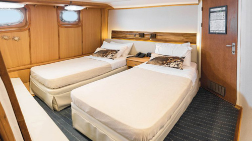
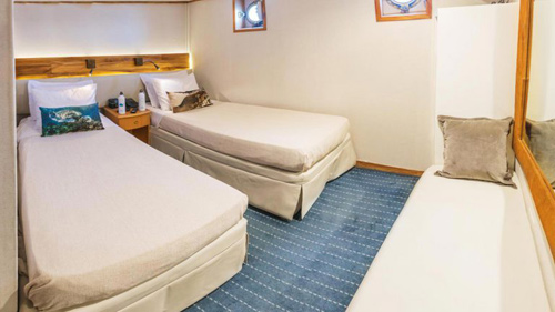
Each of the Coral boat has 3 different cabin categories:
- Standard Cabin (2 cabins in the Coral I)
- Standard Plus Cabin (8 cabins in the Coral I and 4 cabins in the Coral II)
- Junior Cabin (8 cabins in the Coral I and 7 cabins in the Coral II)
All cabin categories include a private bathroom (with hairdryer and toileteries), safe-deposit box, air conditioning, phone (internal calls only) and a TV.
There are cabins with interconnecting doors suitable for families or friends traveling together.
Our voltage is set for 110-220 volts/60 Hz. There are Wi-Fi zones onboard.
 Standard Cabin - measuring an average of 7 m2 / 75ft2
Double and single occupancy possible.
There are 2 portholes in each Standard Cabin.
 Standard Plus Cabin - measuring an average of 11 m2 / 118 ft2
Double and triple occupancy possible.
There are 2 portholes per Standard Plus Cabin.
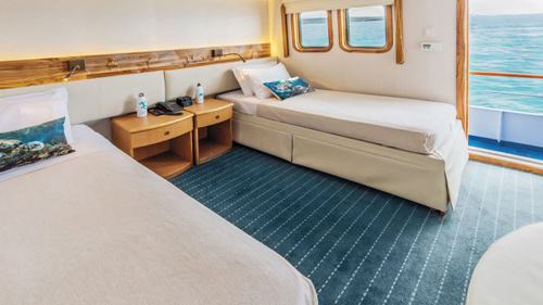 Junior Cabin - measuring an average of 12 m2 / 128 ft2
Double and triple occupancy possible.
Each Junior Cabin has 2 picture windows.
Onboard Service and Facilities include:
• Drying machines available for complimentary use
• Variety of onboard activities
• Briefings on the following day’s activities
• Informative lectures about the Galapagos
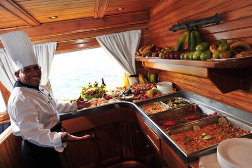 Meals
Meals
All meals are included during the cruise.
The restaurant serves delicious Ecuadorian and international cuisine that even extends to a BBQ dinner on the open-air Moon Deck.
Make the most of your cruise experience with our beverage packages (not included in tour price - to be p[aid extra) that offer a range of soft drinks, local beer, a selection of sparkling wines and classic cocktails to be served at our bars and restaurants.
|
Tack:
|
|
|
|
Horses:
|
|
|
|
Pace:
|
|
|
|
Level:
|
|
(1
to
2
out of 5)
|
|
Riders:
|
|
Min
8 riders
|
Max
36 riders
|
|
Staff
Every crew member is trained to provide a first-class service with exceptional professionalism. Genuinely friendly individuals, fully dedicated to providing the best hospitality services, with attention to detail
and personalized assistance, our crew’s passion and commitment create a one-of-a-kind experience for our guests.
Physical requirement for the cruise
We recommend that passengers be in reasonably good physical condition as some trails are difficult therefore elderly or disabled people may find them too hard. The passengers with difficulties must notify us about their physical condition in order to make the necessary arrangements.
We reserve the right to refuse a passenger if someone failed to inform of any physical disability, or who in the opinion of the company, constitutes a danger to themselves, other guest, members of the crew, or the smooth operation of the vessel.
Dry Landings and Wet Landings
On a dry landing, passengers step directly from a dinghy to rocks or onto a dock. We recommend: walking shoes, sunscreen, hat, water, insect repellent and a light jacket.
Wet Landing means that the dinghy edges up onto a beach, where you step into knee-deep water assisted by crew members and guides. We recommend: swimming suit or shorts, walking shoes or slippers, towel that will be provided by the crew while disembarking, sunscreen, hat, insect repellent, plastic bag, well insulated cameras and a windbreaker.
Smoking policy on board the ship
It is forbidden to smoke inside the yachts or the vessel.
Smoking is allowed ONLY on the sun decks.
How can I pay my expenses on board?
Upon arrival, a bill will be opened for you. If you wish to pay with your credit card, we ask you to come to reception to sign a voucher and to make copies of your passport and credit card. Authorizations take about 48 hours, so please do this on your first cruise day. We accept all main credit cards: Diners, Visa, Mastercard , American Express. Travellers Checks, Euros and US Dollars are also accepted.
What would happen if I get seasick?
We hardly get a seasick passenger on board. However, we have seasick medication on board all our ships, but if you are particularly sensitive you can bring your own medication.
Is the water safe to drink?
The tap water is generally not safe to drink in Ecuador. Bottled water is readily available at tourist sites, hotels, and restaurants. On board our yachts you will find bottled water in your room. Ice used onboard the yachts is generally made with purified water as well.
Passports
Passport valid for at least six months required by all nationals referred to in the chart.
Passport Note
Passports must be carried at all times.
Visas
Not required by all nationals referred to in the chart above for stays of up to 90 days.
Note: (a) A measles vaccination certificate is required by all nationals travelling from Germany and Italy and must be shown on arrival. (b) Nationals not referred to in the chart above are advised to contact the embassy to check visa requirements (see Contact Addresses).
Visa Note
Extensions of a further 90 days are available through the local immigration authorities.
| Passport Required? |
| British |
Yes |
| Australian |
Yes |
| Canadian |
Yes |
| USA |
Yes |
| Other EU |
Yes |
| Visa Required? |
| British |
No |
| Australian |
No |
| Canadian |
No |
| USA |
No |
| Other EU |
No |
| Return Ticket Required? |
| British |
Yes |
| Australian |
Yes |
| Canadian |
Yes |
| USA |
Yes |
| Other EU |
Yes |
This information is not being updated on a regular basis. Hidden Trails does not
take any responsibility for the accuracy of the above information. Please, consult
the embassy or consulate for updated info.
|

|
|
|
Coral I & II 5-day Cruise
Tour Code:
ZZ-EC-GALP04-4
5 days /
4 nights
Dates :
Available all Year
Level :

Difficulty Levels Explained
|
1. |
Easy
|
Easy pace and an average-to-sedentary level of fitness. You should be in good health and fit enough for full day of normal sightseeing and walking.
|
|
2. |
Easy to Moderate
|
An average level of fitness or some experience with the featured
activity is recommended.
|
|
3. |
Moderate
|
Requires you to have performed the featured activity regularly, with
some periods on challenging terrain. Activities are mandatory and
you may be traveling at high elevations. You need to be in good health and physical condition to enjoy these trips, with adequate muscular strength and cardiovascular endurance.
|
|
4. |
Demanding
|
You must be extremely physically fit and are expected to hike or
ride four to six hours over steep or more rugged terrain. |
|
5. |
Strenuous
|
Prolonged hiking/biking on moderate to difficult terrain (five to nine hours a day).
May include high altitude, rugged terrain etc.. |

Introduction
Day to Day Itinerary
Rates | Dates
Accommodation
Tack:
Horses:
Pace:
Airport:
Baltra
Location on Google Map
Image Gallery
Image Slide Show
Customer Trip Rating
Climate
What To Bring
Download tour PDF 
|