|
|
|
|
|
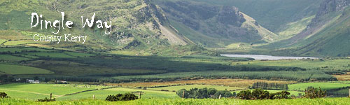
Hiking - Dingle Way
North County Kerry
Ireland
The Dingle Way is a circular route of 179 km (112 miles) circumnavigating the Dingle Peninsula west of Tralee in County Kerry, Ireland. It is one of the first national walking routes (Waymarked Ways) and follows minor roads, traditional access routes to turf cutting areas and forest paths. The only high ascent is 600m, crossing the shoulder of Brandon Mountain between Ballydavid and Cloghane.
Prepare for the vivid colours of purple loosestrife, scarlet fuchsia and orange montbretia. Drop in some wild yellow ragwort, the coconut honeyed scent of gorse and the shades of purple heather and you have a walking destination created by the Divine.
The Dingle Way walking route skirts the mountains of the Slieve Mish range, which form the spine of this 65-km long peninsula, jutting into the Atlantic Ocean. The mountains are rounded, not as high as their nearest neighbours on the Iveragh peninsula and formed from a beautiful old red sandstone, that is always visible in the area.
The peninsula is littered with remains from the early Christian period, oratories, beehive huts, megalithic tombstones, monastic enclosures, high crosses, to name a few.
The town of Dingle (An Daingean) retains its essential character attributed to a working fishing harbour. The steep streets have been reinvented with colourful tourist shops, craft outlets and a host of restaurants and pubs. It is also the centre of one of Ireland’s most popular Gaeltacht regions, where 43% of households are predominantly Gaelic speakers, which adds a wonderful flavour to the local supermarkets!
Otherwise small farming villages populate the peninsula. You will see sheep aplenty, some beef cattle and the occasional small dairy herds. The noticeable construction of new dwelling houses indicates a return to the area of many who left in the 1980’s for economic reasons.
Overnight stops (apart from Dingle) are in villages, allowing an opportunity to experience life with the locals and a chance to try Guinness and Gaelic! Early Christian sites, standing stones, burial mounds etc. will be all along the route – many are nameless clumps of stones and any of significance will be referred to in your route notes.
Tour Highlights
- Brooding mountains, lakes and beaches. Just fantastic scenery.
- Pre and early Christianity… Stones, rows, huts, churches, wells.
- Cloghane & Brandon villages, nestling under the hills and seas.
- Castlegregory & the Magharees, swept by Atlantic winds and tides!
- Fresh, fresh, fresh seafood!
|
Walking Tour
Meeting:
Camp
Airport:
Kerry airport
Transfer:
|
|
|
|
Rates and Dates for 2024
Rates include:
Accommodation; All breakfasts; Luggage transfers; Detailed route descriptions and 1:50000 maps
| A | 2024 | 10 day Self Guided trip | 10d / 9n | €945 | $1040 |
| Single supplement | €395 | $435 |
| B | 2024 | 8 day Self Guided trip | 8d / 7n | €735 | $810 |
| Single supplement | €305 | $335 |
| C | 2024 | 5 day Self Guided trip | 5d / 4n | €420 | $460 |
| Single supplement | €175 | $190 |
�����������������������������������������������������������������������������������������������������������������������������������������������������������������������������������������������������������������������������������������������������������������������������������������������������������������������������������������������������������������������������������������������������������������������������������������������������������������������������������������������������������������������������������������������������������������������������������������������������������������������������������������������������������������������������������������������������������������������������������������������������������������������������������������������������������������������������������������������������������������������������������������������������������������������������������������������������������������������������������������������������������������������������������������������������������������������������������������������������������������������������������������������������������������������������������������������������������������������������������������������������������������������������������������������������������������������������������������������������������������������������������������������������������������������������������������������������������������������������������������������������������������������������������������������������������������������������������������������������������������������������������������������������������������������������������������������������������������������������������������������������������������������������������������������������������������������������������������������������������������������������������������������������������������������������������������������������������������������������������������������������������������������������������������������������������������������������������������������������������������������������������������������������������������������������������������������������������������������������������������������������������������������������������������������������������������������������������������������������������������������������������������������������������������������������������������������������������������������������������������������������������������������������������������������������������������������������������������������������������������������������������������������������������������������������������������������������������������������������������������������������������������������������������������������������������������������������������������������������������������������������������������������������������������������������������������������������������������������������������������������������������������������������������������������������������������������������������������������������������������������������������������������������������������������������������������������������������������������������������������������������������������������������������������������������������������������������������������������������������������������������������������������������������������������������������������������������������������������������������������������������������������������������������������������������������������������������������������������������������������������������������������������������������������������������������������������������������������������������������������������������������������������������������������������������������������������������������������������������������������������������������������������������������������������������������������������������������������������������������������������������������������������������������������������������������������������������������������������������������������������������������������������������������������������������������������������������������������������������������������������������������������������������������������������������������������������������������������������������������������������������������������������������������������������������������������������������������������������������������������������������������������������������������������������������������������������������������������������������������������������������������������������������������������������������������������������������������������������������������������������������������������������������������������������������������������������������������������������������������������������������������������������������������������������������������������������������������������������������������������������������������������������������������������������������������������������������������������������������������������������������������������������������������������������������������������������������������������������������������������������������������������������������������������������������������������������������������������������������������������������������������������������������������������������������������������������������������������������������������������������������������������������������������������������������������������������������������������������������������������������������������������������������������������������������������������������������������������������������������������������������������������������������������������������������������������������������������������������������������������������������������������������������������������������������������������������������������������������������������������������������������������������������������������������������������������������������������������������������������������������������������������������������������������������������������������������������������������������������������������������������������������������������������������������������������������������������������������������������������������������������������������������������������������������������������������������������������������������������������������������������������������������������������������������������������������������������������������������������������������������������������������������������������������������������������������������������������������������������������������������������������������������������������������������������������������������������������������������������������������������������������������������������������������������������������������������������������������������������������������������������������������������������������������������������������������������������������������������������������������������������������������������������������������������������������������������������������������������������������������������������������������������������������������������������������������������������������������������������������������������������������������������������������������������������������������������������������������������������������������������������������������������������������������������������������������������������������������������������������������������������������������������������������������������������������������������������������������������������������������������������������������������������������������������������������������������������������������������������������������������������������������������������������������������������������������������������������������������������������������������������������������������������������������������������������������������������������������������������������������������������������������������������������������������������������������������������������������������������������������������������������������������������������������������������������������������������������������������������������������������������������������������������������������������������������������������������������������������������������������������������������������������������������������������������������������������������������������������������������������������������������������������������������������������������������������������������������������������������������������������������������������������������������������������������������������������������������������������������������������������������������������������������������������������������������������������������������������������������������������������������������������������������������������������������������������������������������������������������������������������������������������������������������������������������������������������������������������������������������������������������������������������������������������������������������������������������������������������������������������������������������������������������������������������������������������������������������������������������������������������������������������������������������������������������������������������������������������������������������������������������������������������������������������������������������������������������������������������������������������������������������������������������������������������������������������������������������������������������������������������������������������������������������������������������������������������������������������������������������������������������������������������������������������������������������������������������������������������������������������������������������������������������������������������������������������������������������������������������������������������������������������������������������������������������������������������������������������������������������������������������������������������������������������������������������������������������������������������������������������������������������������������������������������������������������������������������������������������������������������������������������������������������������������������������������������������������������������������������������������������������������������������������������������������������������������������������������������������������������������������������������������������������������������������������������������������������������������������������������������������������������������������������������������������������������������������������������������������������������������������������������������������������������������������������������������������������������������������������������������������������������������������������������������������������������������������������������������������������������������������������������������������������������������������������������������������������������������������������������������������������������������������������������������������������������������������������������������������������������������������������������������������������������������������������������������������������������������������������������������������������������������������������������������������������������������������������������������������������������������������������������������������������������������������������������������������������������������������������������������������������������������������������������������������������������������������������������������������������������������������������������������������������������������������������������������������������������������������������������������������������������������������������������������������������������������������������������������������������������������������������������������������������������������������������������������������������������������������������������������������������������������������������������������������������������������������������������������������������������������������������������������������������������������������������������������������������������������������������������������������������������������������������������������������������������������������������������������������������������������������������������������������������������������������������������������������������������������������������������������������������������������������������������������������������������������������������������������������������������������������������������������������������������������������������������������������������������������������������������������������������������������������������������������������������������������������������������������������������������������������������������������������������������������������������������������������������������������������������������������������������������������������������������������������������������������������������������������������������������������������������������������������������������������������������������������������������������������������������������������������������������������������������������������������������������������������������������������������������������������������������������������������������������������������������������������������������������������������������������������������������������������������������������������������������������������������������������������������������������������������������������������������������������������������������������������������������������������������������������������������������������������������������������������������������������������������������������������������������������������������������������������������������������������������������������������������������������������������������������������������������������������������������������������������������������������������������������������������������������������������������������������������������������������������������������������������������������������������������������������������������������������������������������������������������������������������������������������������������������������������������������������������������������������������������������������������������������������������������������������������������������������������������������������������������������������������������������������������������������������������������������������������������������������������������������������������������������������������������������������������������������������������������������������������������������������������������������������������������������������������������������������������������������������������������������������������������������������������������������������������������������������������������������������������������������������������������������������������
Rates Note:
A transfer supplement will be added to tours when accommodation in our usual guesthouses is not available. We will of course advise you if this is the only available option to secure a booking.
Transfer and Other Charges:
|
2024
|
Transfers are not available - Make your own way to the start of your tour
|
|
| A |
2024
|
04/03
- 10/15
|
10d / 9n
|
10 day Self Guided trip
|
2
|
Reserve
|
| B |
2024
|
04/03
- 10/15
|
8d / 7n
|
8 day Self Guided trip
|
2
|
Reserve
|
| C |
2024
|
04/03
- 10/15
|
5d / 4n
|
5 day Self Guided trip
|
2
|
Reserve
|
|
Any time during the season.
Rates do not include:
All lunches and dinners; Transfers before and after tour; Entrance fees
Sample Itinerary: 10-day tour - subject to changes
Note: It is also possible to sign up for a shorter tour (8 days or 5 days).
Day 1: Travel to Camp
Make your own way to Camp, overlooking Tralee Bay to the north with the majestic Gearhane and Caherconree peaks to the east. It has been an historic crossing point of the Slieve Mish Mountains since the first settlers were here in 1700BC . Camp is a small settlement, with plenty of local colour and a short circular walk to limber up for the kilometers ahead!
Overnight in Camp Village
Meals Included: none
Day 2: Camp to Anascaul via Inch Strand
Hike to the south on turf cutting roads, through the glorious bogland of Slieve Mish- the wilderness of the blanket bog is punctuated with conifer forest and the stacks of drying turf. Skirt Ardroe Hill, overlooking the magnificent 8-km of sand dunes and beach at Inch, with views south to the Ring of Kerry and Ireland’s highest mountain range, before following the “Maum” (pass) down to Annascaul village.
An optional extra hike over Brackaloon Hill adds 5 km (2 hours).
Walking Distance 18.5 km (about 6 hours) / Ascent 460 m
Overnight in Annascaul
Meals Included: Breakfast
Day 3: Anascaul to Dingle
Follow Acres Hill to the staunch remains of 12th century Minard Castle, mostly destroyed by Cromwell’s army in 1650. Turn inland again on minor roads to the railway village of Lispole. All the way you are within scent of the seas of Dingle Bay and encircled by the Kerry Mountains. From Lispole, the Way follows mostly sheep farming country before climbing An Cnoc Maol Mor and descending the old green droving road into Dingle town.
Walking Distance 23 km (about 6.5 hours) / Ascent 560 m
Overnight in Dingle
Meals Included: Breakfast
Day 4: Dingle to Dunquin
Minor roads take you from Dingle to Ventry; beyond is some of the most spectacular scenery you could hope to find. Cross the magnificent Ventry harbour, weave through fuchsia hedges and climb an old track on the foothill of Mount Eagle past the early Christian beehive huts at Fahan. Behind are views south to the Ring of Kerry and Valentia Island. Ahead the route opens up to Slea Head and the Blasket Islands. This is the most westerly point in Europe, beyond is North America!
Optional route over Mount Eagle adds 5 km and 2 hours (we include notes for this climb, only advisable in good weather conditions)
Walking Distance 25 km (about 7 hours) / Ascent 650 m
Overnight in Dunquin
Meals Included: Breakfast
Day 5: Dunquin to Ballydavid
We recommend a visit to the Blasket Island Interpretative Centre before departing Dunquin. This facility illustrates the harshness of life on the Blasket Islands until the last inhabitants resettled to the mainland in 1953.
The route follows the Norse named Smerwick Harbour and a detour takes you to Dun an Oir, the Fort of Gold, where Italian and Spaniard soldiers were besieged by troops of Elizabeth I in 1580.
Your destination for the day is Ballydavid, a thriving fishing harbour and a Gaelic speaking community.
Optional route over Cruach Mharthain adds 1 hour.
Walking Distance 16 km (about 5 hours) / Ascent 240 m
Overnight in Boherboy or Feonanagh (+3-5km from Ballydavid village)
Meals Included: Breakfast
Day 6: Ballydavid to Cloghane
You are in the cradle of early Christian civilization here, with as many as sixty notable sites of cultural and religious development from the 5th to 9th centuries. Today’s hike takes you upto the saddle of Mas an Tiompain (the Pass of the Drum) below Mount Brandon, Ireland’s second highest mountain at 950m. The scenery is superb – Tralee Bay, the Magharees against the hues of the Slieve Mish mountains. The descent to Cloghane is nothing short of thrilling on a clear day, and well-earned respite is available in the village!
Walking Distance 22 km (about 7.5 hours) / Ascent 750 m
Overnight in Cloghane
Meals Included: Breakfast
Day 7: Free Day in Cloghane
You can choose to climb Mount Brandon, Ireland’s second highest mountain (ascents 950 m / 8 hours return), only recommended in good weather and to experienced hikers.
Alternatively, walk to the Valley of Loch a Dúin, inhabited from the early Bronze Age. What is important in the valley is an unbroken line of habitation for 4000 years. There are approximately eighty stone structures, wedge tombs, standing stones, cooking sites or fulacht fia and rock art.
Walking Distance 10 km (about 4 hours) / Ascent 100 m
Overnight in Cloghane
Meals Included: Breakfast
Day 8: Cloghane to Castlegregory
Back at sea level, today’s walk follows the coast around the Castlegregory promontory via the surfing beaches of Brandon and Scraggane Bay to the limestone Isles of Magharee. The fishing harbour of Kilshannig is one of the last places where the traditional namhog is made – a fishing boat with a tarred canvas skin on a light wooden frame. Crabs caught freshly here are transported to the tables of France and Spain. A cross slab bearing the Greek Chi-Rho symbol of Christ is in the 15th century Kilshannig Church.
Walking Distance 13 or 28 km (about 4 or 7 hours) / Ascent 30 m
Overnight in Castlegregory
Meals Included: Breakfast
Day 9: Castlegregory to Camp
A nice coastal route along Tralee Bay.
The optional route (8 km / Ascents 20m. Approximate walking time 2 hours) visits the deserted village of Killelton, its inhabitants evicted by their landlord in the 19th century. There are also the remains of a 12th century oratory. It is a wonderful place with immense views of Tralee Bay.
Walking Distance 12 km (about 3 hours) / Ascent 80 m
Overnight in Camp
Meals Included: Breakfast
Day 10: Departure
Make your own transfer arrangements from Camp.
Meals Included: Breakfast
--------------------------------------
Sample Itinerary: 8-day tour - subject to changes
Day 1: Travel to Camp
Make your own way to Camp, overlooking Tralee Bay to the north with the majestic Gearhane and Caherconree peaks to the east. It has been an historic crossing point of the Slieve Mish Mountains since the first settlers were here in 1700BC . Camp is a small settlement, with plenty of local colour and a short circular walk to limber up for the kilometers ahead!
Overnight in Camp Village
Meals Included: none
Day 2: Camp to Anascaul via Inch Strand
Hike to the south on turf cutting roads, through the glorious bogland of Slieve Mish- the wilderness of the blanket bog is punctuated with conifer forest and the stacks of drying turf. Skirt Ardroe Hill, overlooking the magnificent 8-km of sand dunes and beach at Inch, with views south to the Ring of Kerry and Ireland’s highest mountain range, before following the “Maum” (pass) down to Annascaul village.
An optional extra hike over Brackaloon Hill adds 5 km (2 hours).
Walking Distance 18.5 km (about 6 hours) / Ascent 460 m
Overnight in Annascaul
Meals Included: Breakfast
Day 3: Anascaul to Dingle
Follow Acres Hill to the staunch remains of 12th century Minard Castle, mostly destroyed by Cromwell’s army in 1650. Turn inland again on minor roads to the railway village of Lispole. All the way you are within scent of the seas of Dingle Bay and encircled by the Kerry Mountains. From Lispole, the Way follows mostly sheep farming country before climbing An Cnoc Maol Mor and descending the old green droving road into Dingle town.
Walking Distance 23 km (about 6.5 hours) / Ascent 560 m
Overnight in Dingle
Meals Included: Breakfast
Day 4: Dingle to Dunquin
Minor roads take you from Dingle to Ventry; beyond is some of the most spectacular scenery you could hope to find. Cross the magnificent Ventry harbour, weave through fuchsia hedges and climb an old track on the foothill of Mount Eagle past the early Christian beehive huts at Fahan. Behind are views south to the Ring of Kerry and Valentia Island. Ahead the route opens up to Slea Head and the Blasket Islands. This is the most westerly point in Europe, beyond is North America!
Optional route over Mount Eagle adds 5 km and 2 hours (we include notes for this climb, only advisable in good weather conditions)
Walking Distance 25 km (about 7 hours) / Ascent 650 m
Overnight in Dunquin
Meals Included: Breakfast
Day 5: Dunquin to Ballydavid
We recommend a visit to the Blasket Island Interpretative Centre before departing Dunquin. This facility illustrates the harshness of life on the Blasket Islands until the last inhabitants resettled to the mainland in 1953.
The route follows the Norse named Smerwick Harbour and a detour takes you to Dun an Oir, the Fort of Gold, where Italian and Spaniard soldiers were besieged by troops of Elizabeth I in 1580.
Your destination for the day is Ballydavid, a thriving fishing harbour and a Gaelic speaking community.
Optional route over Cruach Mharthain adds 1 hour.
Walking Distance 16 km (about 5 hours) / Ascent 240 m
Overnight in Boherboy or Feonanagh (+3-5km from Ballydavid village)
Meals Included: Breakfast
Day 6: Ballydavid to Cloghane
You are in the cradle of early Christian civilization here, with as many as sixty notable sites of cultural and religious development from the 5th to 9th centuries. Today’s hike takes you upto the saddle of Mas an Tiompain (the Pass of the Drum) below Mount Brandon, Ireland’s second highest mountain at 950m. The scenery is superb – Tralee Bay, the Magharees against the hues of the Slieve Mish mountains. The descent to Cloghane is nothing short of thrilling on a clear day, and well-earned respite is available in the village!
Walking Distance 22 km (about 7.5 hours) / Ascent 750 m
Overnight in Cloghane
Meals Included: Breakfast
Day 7: Cloghane to Camp
Back at sea level, today’s walk follows the coast, all the way around the Castlegregory promontory if you desire, or across the neck of the spit via Lough Gill, home to Bewick swans and Natterjack toads. From Castlegregory village, mudflats and turf cuttings, quiet coastal paths give way to farmland and a climb back to Camp.
Walking Distance 22 or 32 km (about 6 or 8 hours) / Ascent 30 m
Overnight in Camp
Meals Included: Breakfast
Day 8: Departure
Make your own transfer arrangements from Camp.
Meals Included: Breakfast
--------------------------------------
Sample Itinerary: 5-day tour - subject to changes
Day 1: Travel to Dingle
Make your own way to Dingle.
Limber up with a local circuit walk on Ballysitteragh Hill. This is a strenuous but very rewarding walk, with fabulous views of Dingle town and harbour; on a good day you can see most of the peninsula. It is not compulsory to complete the full round trip, you can walk as far as you feel comfortable with and return the same way.
Alternatively, you can go for a walk around Dingle harbour, by the shoreline (6km. No ascents. Approximate walking time 2 hours).
Walking Distance 19 km (about 6.5 hours) / Ascent 630 m
Overnight in Dingle
Meals Included: none
Day 2: Dingle to Dunquin
Minor roads take you from Dingle to Ventry; beyond is some of the most spectacular scenery you could hope to find. Cross the magnificent Ventry harbour, weave through fuchsia hedges and climb an old track on the foothill of Mount Eagle past the early Christian beehive huts at Fahan. Behind are views south to the Ring of Kerry and Valentia Island. Ahead the route opens up to Slea Head and the Blasket Islands. This is the most westerly point in Europe, beyond is North America!
Optional route over Mount Eagle adds 5 km and 2 hours (we include notes for this climb, only advisable in good weather conditions)
Walking Distance 25 km (about 7 hours) / Ascent 650 m
Overnight in Dunquin
Meals Included: Breakfast
Day 3: Dunquin to Ballydavid
We recommend a visit to the Blasket Island Interpretative Centre before departing Dunquin. This facility illustrates the harshness of life on the Blasket Islands until the last inhabitants resettled to the mainland in 1953.
The route follows the Norse named Smerwick Harbour and a detour takes you to Dun an Oir, the Fort of Gold, where Italian and Spaniard soldiers were besieged by troops of Elizabeth I in 1580.
Your destination for the day is Ballydavid, a thriving fishing harbour and a Gaelic speaking community.
Optional route over Cruach Mharthain adds 1 hour.
Walking Distance 16 km (about 5 hours) / Ascent 240 m
Overnight in Boherboy or Feonanagh (+3-5km from Ballydavid village)
Meals Included: Breakfast
Day 4: Ballydavid
You are in the cradle of early Christian civilization here, with as many as sixty notable sites of cultural and religious development from the 5th to 9th centuries. An optional hike takes you up; up to the saddle of Mas an Tiompain (the Pass of the Drum) below Mount Brandon, Ireland’s second highest mountain at 950m. The scenery is superb – Tralee Bay, the Magharees against the hues of the Slieve Mish mountains. There are several local hikes including Ballydavid Head taking in the spectacular 9th century stone fort of Cathair Fionnurach.
Walking Distance 14 km (about 5 hours) / Ascent 750 m
Overnight in Ballydavid
Meals Included: Breakfast
Day 5: Departure
This morning, transfer from your accommodation back to Dingle town (10 minutes). Then, make your own transfer arrangements from Dingle.
Meals Included: Breakfast
|
|
|
Meeting:
|
|
Camp
|
|
Airport:
|
|
Kerry airport
|
|
Transfer:
|
|
|
|
Level:
|
|
 Moderate Moderate
|
|
Participants:
|
|
Min
2
participants
|
|
|
Time of Year:
You can walk this route anytime between April and October.
The beginning and end of the season will have shorter daylight hours and a higher risk of unpredictable weather.
Knowledge of map reading and using a compass is required.
In May and October, local restaurants may be closed. Your host will assist you with arrangements for an evening meal.
You will enjoy this trip if you are physically fit and like to hike. The hikes each day will vary from 12-24 km (8-15 miles) and cross some rough, wet and rocky terrain. Experience of hiking is a necessity and knowledge of compass use is an advantage.
Passport valid for at least three months beyond length of stay required by all except:(a) 1. persons born in the UK travelling direct from the UK (applicable to British passport holders only).Note: Wh. more
Dingle area
|
Month
|
Jan
|
Feb
|
Mar
|
Apr
|
May
|
Jun
|
Jul
|
Aug
|
Sep
|
Oct
|
Nov
|
Dec
|
|
Average High Temperature (°F)
|
52
|
51
|
53
|
56
|
60
|
64
|
66
|
67
|
65
|
60
|
55
|
53
|
|
Average Low Temperature (°F)
|
42
|
42
|
43
|
45
|
49
|
53
|
56
|
56
|
54
|
50
|
46
|
44
|
|
Average High Temperature (°C)
|
11
|
11
|
12
|
14
|
16
|
18
|
19
|
19
|
18
|
16
|
13
|
12
|
|
12Average Low Temperature (°C)
|
6
|
5
|
6
|
7
|
9
|
12
|
14
|
14
|
12
|
10
|
8
|
7
|
|
Average Precipitation (days of rain)
|
20
|
16
|
17
|
13
|
13
|
13
|
13
|
14
|
15
|
18
|
20
|
19
|
Source: NOAA
Seasons
Ireland has a reputation of being wet but it is also famous for having 40 shades of green! The expression "a soft day" is a popular one with the Irish and describes light rain in mild temperatures. Because of the Atlantic Ocean and Gulf Stream, the weather can be very unpredictable, so waterproof rainwear is essential. The temperatures can range from 5° - 19° Celsius and the highest will rarely go over 25° Celsius.
Due to the high humidity it can get very warm in summer but on higher ground it can suddenly become colder due to the wind-chill factor.
We will supply you with colour copies of the relevant sections of the Ordnance Survey maps 51 and 57; scale 1: 50.000. You will also have detailed text descriptions of each days’ walk and information on where you are staying and where you can eat.
Your hosts are responsible for transferring your luggage to the next accommodation. It should be there by 4 pm or before you finish your walk. Please appreciate that accommodations are often busy with preparing their premises for new guests and transferring luggage is a service only provided for walkers. Occasionally your luggage will not be there before you arrive but it does always arrive. In some places you might have a voucher for a taxi company who will be transferring the luggage, as it is not a service the accommodation provides.
PLEASE PACK ONLY ONE ITEM OF LUGGAGE PER PERSON. Make sure your luggage is clearly marked with your name on it, as sometimes the accommodation will be transferring luggage for more than one walking company and to more than one accommodation.
You will require probably ALL of the following:
- Fully waterproof rainwear;
- Waterproof hiking boots;
- Hiking-pole;
- Light walking shoes;
- Spare layer of clothing;
- Hat/cap;
- Gaiters;
- Day-rucksack;
- Thermos flask;
- Water bottle;
- Lunchbox;
- Plastic bag;
- Torch; Insect-repellent spray;
- First Aid kit;
- Blister-plaster;
- Sunscreen.
On mountain walks you will need strong boots with ankle support but on road walking you may be able to wear lighter boots or shoes. You can usually determine what footwear you require at the start of each day. Heavy mountain boots will be uncomfortable for road walking. You may wish to carry a light pair of shoes in your day-pack.
If you are familiar with using a compass, do bring one. It is very important if you follow suggested alternative routes, or if you are walking in poor weather.
We strongly advocate the use of one or two hiking poles, for your comfort and safety.
Sorry, no video is currently available for this tour.
*Important Notice: The following ratings have been submitted by guests and do not necessarily represent the views of Hidden Trails, its partners or employees.
Every care is taken to ensure accuracy but Hidden Trails is not liable for any errors or omissions.
..view other reports for different trips
Accommodations
This is a progressive tour so nights will be spent in different locations.
Description
You will be staying in comfortable guesthouses and farmhouses. Rooms are as much as possible en-suite. However B&B’s do still have rooms that are not en-suite but should have a bathroom adjacent to the room. We will book these rooms when there are no en-suites available. This happens regularly in the high season.
We do try to make your accommodation convenient to each day’s walk. The walking distances for each day as specified in your tour itinerary may vary, depending where you are staying, as your accommodation may not be in the centre of the village. This will be referred to in your route notes and may add 2-3 km to your walk. Please check this before you walk!
While we have reserved your accommodation, it is a good idea to telephone your hosts with the approximate time of your arrival. Some accommodations will offer you tea or coffee on arrival – if they don’t please do ask if you would like some. You will find that hosts are very approachable and sometimes you just need to ask for what you want.
You must show your accommodation list to your host each day on your arrival. Your luggage will be transferred for you each day by the guesthouse owners or taxi.
Accommodation Itinerary for 10-day tour - subject to changes based on availability
Night 1: Accommodation in Camp
Night 2: Accommodation in Annascaul
Night 3: Accommodation in Dingle
Night 4: Accommodation in Dunquin
Night 5: Accommodation in Boherboy or Feonanagh
Night 6 & 7: Accommodation in Cloghane
Night 8: Accommodation in Castlegregory
Night 9: Accommodation in Camp
Accommodation Itinerary for 8-day tour - subject to changes based on availability
Night 1: Accommodation in Camp
Night 2: Accommodation in Annascaul
Night 3: Accommodation in Dingle
Night 4: Accommodation in Dunquin
Night 5: Accommodation in Boherboy or Feonanagh
Night 6: Accommodation in Cloghane
Night 7: Accommodation in Camp
Accommodation Itinerary for 5-day tour - subject to changes based on availability
Night 1: Accommodation in Dingle
Night 2: Accommodation in Dunquin
Night 3 & 4: Accommodation in Boherboy or Feonanagh
Room Occupancy
If you are travelling alone, you will be booked into a single room in your accommodations. This is often a room for two persons that you will have to yourself, which means a single supplement fee needs to be applied.
Please, note that a single traveller also incurs the full luggage transfer fee, which is normally divided between two people.
It is a good idea to contact your hosts and let them know what time you expect to arrive – they tend to be more concerned about walkers hiking alone.
Meals
Only breakfasts are included in your package.
Ireland is renowned for its “Full Irish Breakfast” which consists of bacon, sausages, fried egg and toast. Cereals or a lighter option might be available if you ask. Some walkers find the “full Irish” too much every morning. You can agree with your host on your arrival what time you want breakfast – this is usually between 8.00 and 9.00am.
You can enjoy evening meals in the guesthouses in some locations (for an extra fee), but the hosts need to be notified beforehand. If you choose to eat with your hosts in their home, please ring them the previous evening, or the morning before you arrive to book a meal. They may have to travel some distance to get supplies! Please ask your hosts for any advice in relation to the best places to eat if you wish to eat out and where to find traditional entertainment.
In the early or late season, local restaurants may be closed or pubs may not be serving evening meals. Your hosts will assist you with alternative arrangements if you are walking in the off-season.
Lunches such as sandwiches or filled rolls are often available in local shops or supermarkets, and many also have hot food counters. Look for names such as Centra, Londis, Statoil, Spar, or check in petrol stations. Please note that it is advisable to carry lunch with you unless told otherwise in the route notes.
Do tell your hosts when you arrive if you would like them to provide a packed lunch for the next day (extra fee applies).
|
Tack:
|
|
|
|
Horses:
|
|
|
|
Pace:
|
|
|
|
Level:
|
|
 (3
to
3
out of 5) Moderate
(3
to
3
out of 5) Moderate
|
|
Riders:
|
|
Min
2
|
|
Time of Year:
You can walk this route anytime between April and October.
The beginning and end of the season will have shorter daylight hours and a higher risk of unpredictable weather.
Knowledge of map reading and using a compass is required.
In May and October, local restaurants may be closed. Your host will assist you with arrangements for an evening meal.
You will enjoy this trip if you are physically fit and like to hike. The hikes each day will vary from 12-24 km (8-15 miles) and cross some rough, wet and rocky terrain. Experience of hiking is a necessity and knowledge of compass use is an advantage.
Passports
Passport valid for at least three months beyond length of stay required by all except:
(a) 1. persons born in the UK travelling direct from the UK (applicable to British passport holders only).
Note: Whilst UK citizens do not require a passport or visa to enter Ireland, most carriers by air or sea now require some form of identification with photograph, usually a passport or driving licence with photo. Visitors should check what form of ID is required with the individual airline, ferry company or travel agent before travelling.
(b) 2. EU nationals holding a valid national ID card.
Note: EU nationals are only required to produce evidence of their EU nationality and identity in order to be admitted to any EU Member State. This evidence can take the form of a valid national passport or national identity card. Either is acceptable. Possession of a return ticket, any length of validity on their document, sufficient funds for the length of their proposed visit should not be imposed.
Passport Note
3. Imposition of a return ticket as a condition of entry is at the discretion of the Immigration Officer at point of entry.
Visas
Not required by all nationals referred to in the chart above for the following durations:
(a) nationals of EU countries for an unlimited period (nationals of EU countries wishing to stay for longer than three months must register with the Garda National Immigration Bureau).
(b) nationals of Australia, Canada and the USA for stays of up to 90 days.
Note: Nationals not referred to in the chart above are advised to contact the embassy to check visa requirements
| Passport Required? |
| British |
1 |
| Australian |
Yes |
| Canadian |
Yes |
| USA |
Yes |
| Other EU |
2 |
| Visa Required? |
| British |
No |
| Australian |
No |
| Canadian |
No |
| USA |
No |
| Other EU |
No |
| Return Ticket Required? |
| British |
No |
| Australian |
3 |
| Canadian |
3 |
| USA |
3 |
| Other EU |
No |
|

|
|
|
Hiking - Dingle Way
Tour Code:
ZZ-OUT-38
10 days /
9 nights
~$1,040.00
Dates: April to October
Trip Rating :

Level :

Difficulty Levels Explained
|
1. |
Easy
|
Easy pace and an average-to-sedentary level of fitness. You should be in good health and fit enough for full day of normal sightseeing and walking.
|
|
2. |
Easy to Moderate
|
An average level of fitness or some experience with the featured
activity is recommended.
|
|
3. |
Moderate
|
Requires you to have performed the featured activity regularly, with
some periods on challenging terrain. Activities are mandatory and
you may be traveling at high elevations. You need to be in good health and physical condition to enjoy these trips, with adequate muscular strength and cardiovascular endurance.
|
|
4. |
Demanding
|
You must be extremely physically fit and are expected to hike or
ride four to six hours over steep or more rugged terrain. |
|
5. |
Strenuous
|
Prolonged hiking/biking on moderate to difficult terrain (five to nine hours a day).
May include high altitude, rugged terrain etc.. |

Introduction
Day to Day Itinerary
Rates | Dates
Accomodation
Airport:
Kerry airport
Location on Google Map
Image Gallery
Image Slide Show
Climate
What To Bring
Download tour PDF 
↑ Back to Top
|