Hiking
tours
in Ireland
Join Hidden Trails on an Ireland walking tour or hiking trip. This is the Ireland we would like you to experience. Quiet villages, small laneways, beautiful scenery, colorful wildlife, and at the end of each day, Irish hospitality in our guesthouses and hostelries. Ireland is steeped in history and in every town, in name and place, there will be a story of battle, or religious dispute or of pure imagination and legend! From the Irish saints of the early centuries to the modern scholars of the twenty-first, an indelible mark has been made, which makes Ireland what it is.
Our Irish guided hiking tours will take you on daily hikes, accompanied by a guide and support vehicle, giving you great flexibility and the opportunity to see much of the countryside. We have six guided hiking tours to choose from: West Coast Walks, Hidden Ireland North, Hidden Ireland South, Discover Ireland North, Discover Ireland South and Northern Shores Walk.
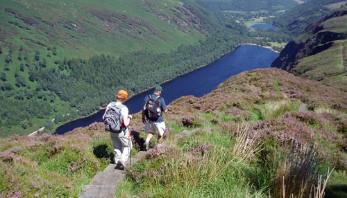
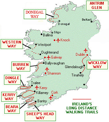
On our self guided tours, walks are from 10 to 15 miles (4-8 hours). You can hike on your own or bring a bunch of friends. With our color OS maps you'll have no problem finding your way. You can choose when to go and for how long. Our self guided tours follow an excellent network of walks: Wicklow Way, Kerry Way, Sheep’s Head Way, Dingle Way, Burren Way, Beara Way, Connemara Western Way and Donegal Way.
We have a range of tours all over the country and several can easily be combined for a longer visit.
We book your guesthouses, they organize your luggage transfers each day, all you have to do is walk and enjoy the views. Bed & Breakfast accommodation, luggage transfers and detailed route description with maps are included. You are as free as a bird.
We will provide you with 1 information tour package with maps etc for every 2 participants. Additional packages can be purchased for Euro 35 each.
 |
|
HIKES IN IRELAND
|
Self-Guided Walking Holidays on our National Waymarked Ways - we do the planning and organizing, you do the walking!
Explore more Europe Hiking Vacations
Hiking holidays in Ireland